I was talking with my group of graduate students about John Muir’s essays originally written for newspapers, published in the collection Travels in Alaska (1915). Muir developed a hypothesis during the 1870s revising accounts of how the geological landscape of the Western U.S.A. was formed: he was sure that the canyons and valleys were the result of glaciation, and not of a massive earthquake (the accepted theory at the time). The first of his five trips to Alaska (1879) enabled him to test that hypothesis by observing and measuring existing glaciers and examining their moraine. Muir (b. 1838) was a first generation Scottish immigrant who had ‘gone west’ to California after moving with his family to Wisconsin from Dunbar, near Edinburgh, aged eleven. He became intrigued by the geological – and bioregional – connectedness of the most northern U.S. State and the worn-away landscapes of the more familiar South West, writing about the continuum of erosion that could still be seen taking place. While noting that the flora and fauna at such different latitudes had few species in common, Muir compared the mineral and ecological structures of Alaskan river and glacial canyons to those in Yosemite. One such comparison of the Stickeen river valley shows his characteristic interweaving of scientific analysis and aesthetics:
The majestic cliffs and mountains forming the cañon walls display endless variety of form and sculpture, and are wonderfully adorned and enlivened with glaciers and waterfalls, while throughout almost its whole extent the floor is a flowery landscape garden, like Yosemite (Ch. IV, ‘The Stickeen River’).
After persuading the captain of the steamship on which he was travelling to make a digression during a return journey to Wrangell, Muir takes that comparison a stage further into a narrative suggestive of geological time travel:
On either hand rise a series of majestic, pale-gray granite rocks from three to four thousand feet high, some of them thinly forested and striped with bushes and flowery grass on narrow shelves, especially about half way up, others severely sheer and bare and built together into walls like those of Yosemite, extending far beyond the ice barrier, one immense brow appearing beyond another with their bases buried in the glacier. This is a Yosemite Valley in process of formation, the modeling and sculpture of the walls nearly completed and well planted, but no groves as yet or gardens or meadows on the raw and unfinished bottom. It is as if the explorer, in entering the Merced Yosemite, should find the walls nearly in their present condition, trees and flowers in the warm nooks and along the sunny portions of the moraine-covered brows, but the bottom of the valley still covered with water and beds of gravel and mud, and the grand glacier that formed it slowly receding but still filling the upper half of the valley. (Ch. V, ‘A Cruise in the Cassiar’).
Nowadays spelled ‘Stikine,’ that river and its canyons are still described as a ‘wilderness area.’ Wilderness being a marketable commodity, the designation is undermined by the availability of tourism, including jet boat hire and bear observatories, and the fact that the area had long been home to native Canadians. The name Stikine is a transcription of the Tlingit for ‘great river.’
Travels in Alaska represents episodes from the voyages that Muir made in 1879, 1880 and 1890. Motifs of ice, rock, rivers, salmon, trees, plants and skies shape the essays, along with anthropological accounts of the lives of First Nations Canadians. A sense of wonder at the magnitude of the Alaskan landscape informs the collection, from the ‘vast expanse of open rolling prairie like highlands’ (Ch. 6, ‘The Cassiar Trail’) and ‘the glittering bergs, the crystal bluffs of the vast glacier, and the intensely white, far-spreading fields of ice’ (Ch. 10, ‘The Discovery of Glacier Bay’), to the ‘ice-cliffs, pinnacles, spires and ridges’ that suggest ‘a magnificent picture of nature’s power and industry’ (Ch. XVII, ‘In Camp at Glacier Bay,’ 1890 trip). At the same time, moments of quiet familiarity include the botanical cataloguing of species also found southwards throughout the river valleys and mountains of British Columbia and the western states of the U.S.: cottonwoods, willows and aspens.
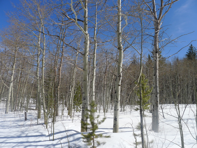
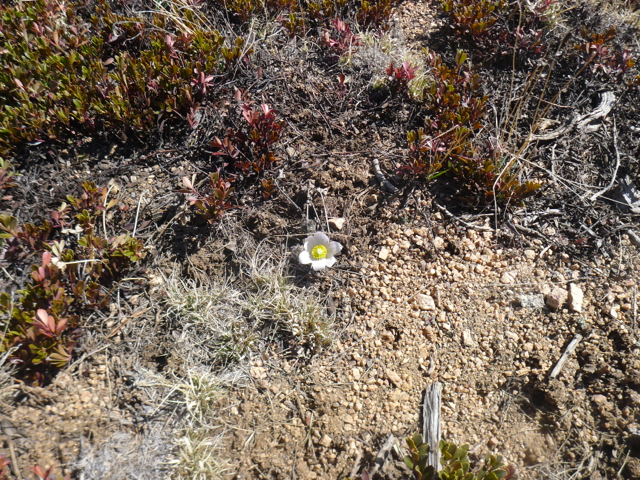
I’d spent the day before our discussion hiking at Vedauwoo, in the Medicine Bow-Routt National Forest near to Laramie. The trails in this area of dramatic, Precambrian Sherman Granite formations are popular with walkers, as are the rocks with climbers, but if you go midweek in April you will feel that you have the place more or less to yourself. I’ve been here three times and seen almost no-one. The road through from Happy Jack was closed and snow still blocked the car park, but the thaw and clear sunshine gave a sense of spring that was confirmed by the aspen buds, willow catkins, and a solitary pasque flower.
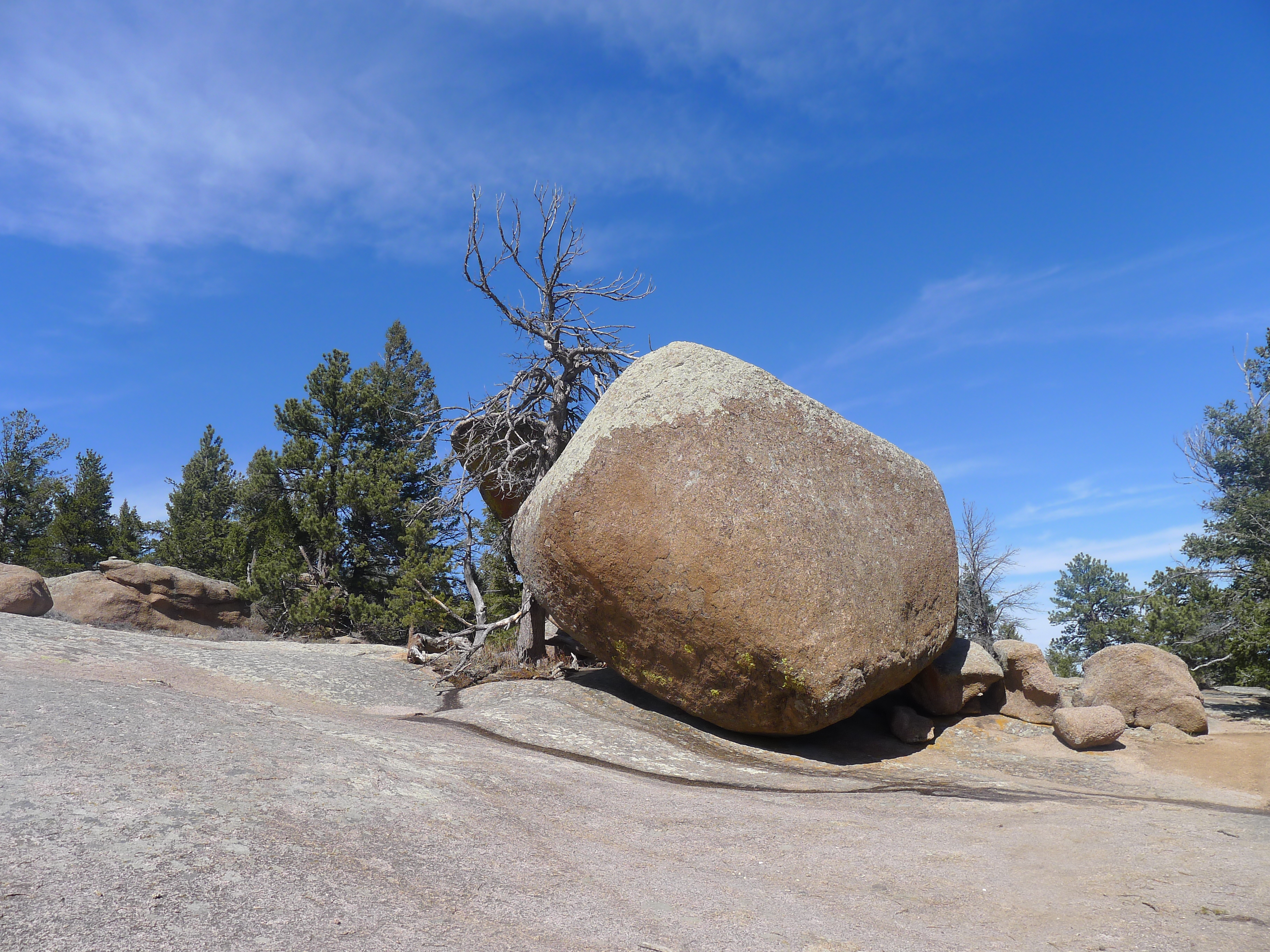
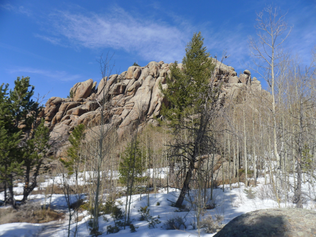
Vedauwoo is scared to the Arapahoe, who call it ‘earth-born,’ and, by extension, ‘place of the earth-born spirits.’ The hoodoos and other rock formations are spectacular, providing stunning scenery at an elevation of around 8,200 to 8,400 feet. As the University of Wyoming points out, the rocks are among the oldest in the state at 1.4 billion years but are still only half the age of the Teton mountains. It isn’t difficult to see why Wyoming is such a paradise for geologists.

We took the Turtle Rock trail in reverse, beginning with a grove of aspens close to some beaver ponds.
There were no signs of beaver activity, but birds included Mountain Chickadees and, I believe, a golden eagle soaring around Turtle Rock. A ground squirrel ran into a hole under some rocks. The route winds around the main outcrop of Turtle Rock to an area where pink boulders, some of them almost the size of small houses, balance on top of huge, smooth flat slabs.
Lichens thrive on these rock surfaces. It pays to watch your footwork, as you can easily slip. That part of the trail leads through a marshy track of land with streams into an undulating forest path through mainly Ponderosa Pines (with some Limber pine, Spruce, and Douglas fir) and more large boulders. The effects of pine beetle can be seen.

Snow melt has exposed areas of grass that are showing signs of green and it was here that I found the solitary pasque flower. Other vegetation is mainly sagebrush.
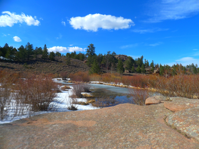
The view of the boulder and main outcrops are spectacular all along the trail, but in this section there are extensive views across the glacially eroded valley toward the Sherman Mountains and Happy Jack (another area with plenty of hiking trails). Descending, the forest path opens out onto an area of interlinking ponds with willow and more aspens. A sound of running water broke the silence, with the ice melting under the azure sky into dark, ultramarine pools of water rippled by the still-frigid wind. Moose often feed here, but all we saw was deer scat and a variety of footprints.

We continued through another aspen grove to an extensive area of rough boulders and granite outcrops back to the sheer walls of Turtle Rock, turning upward through fields of hoodoos to end the hike.
Rather than return home immediately, we took a dirt road to explore an area of high plains shortgrass prairie. Along this open, almost treeless track (with only stunted pines and some cottonwoods, willows and aspens in the few, sheltered ravines) were raptors – at least two different kinds of hawk – but I was unable to identify them. A roan Texas longhorn steer looked at us from behind a fence. The wind was more relentless here than at Vedauwoo, and it felt as if we were at the top of the world. On the other side of the pastel green, tawny and red stretch of the prairie and valley, the Snowy Mountains shimmered under the sun.

* Travels in Alaska was edited and published the year after Muir’s death, by his friend and biographer William Badè. I’ve referred here to the original edition published by Houghton Mifflin and made available online by the Sierra Club at http://www.sierraclub.org/john_muir_exhibit/writings/travels_in_alaska/