

‘Our heated sidewalks and dressing room floors keep your toes toasty warm, even on the coldest of nights.’ (www.lavahotsprings.com).
‘Welcome to the sagebrush steppe’ (information board, roadside rest area near Atomic City).
‘We’re praying for rain. There was hardly any snow this year and the reservoirs are low.’ (women in a roadside cafe, Carey)
How to begin is the question. Crossing the Wyoming border into Idaho between Cokeville Meadows National Wildlife Refuge and Montpelier starts an extraordinary exploration of a landscape defined on the one hand by man’s capacity for self-destruction and on the other by a demonstration of the damage that nature can wreak. Nature wins. At least, so far. . .

Mountains and pastoral rangelands roll on either side of the Portneuf River valley, with its motel-studded, bijou spa towns of Soda Springs and Lava Hot Springs. Soda Springs has a geyser and naturally carbonated water, while Lava Hot Springs attracts bathers and pipes geothermally heated water into homes. Shoshone and Bannock Native Americans used these springs for centuries, before the ‘hot tubs’ were discovered by fur trappers and mountain men (working for the American Pacific Fur Company and the North West and Hudson’s Bay companies), then by pioneers and settlers. French-Canadian fur trappers named the river some time before 1821. The road follows part of the old Oregon and California trails, and is a goldmine of historical interest. Farmsteads and honeymoon hotels wear a comforting Sunday best of homeliness and hopefulness.
On the other hand, all these places obscure their own past: they were carved out of the sagebrush steppe and high desert that closes in on every side. The land is irrigated and its soil has been artificially enriched, while the Portneuf River, a tributary of the Snake, has been described as a ‘heavily used and anthropogenically altered system,’ in which nitrate discharges from cattle ranching along with other forms of use by the local populations ‘have produced a unique set of chemical characteristics associated with both the biological processes and the interactions with the local geology’ (Wikipedia, ‘The Pontneuf River’). The vast Snake River Basin stretches westward as far as the eye can see from Pocatello (population 54,777 in 2012), the third largest city in Idaho after Boise and Idaho Falls. But as we drive out beyond the smaller western town of Blackfoot into what seems a plain of desolation, other power sources are just over the horizon.
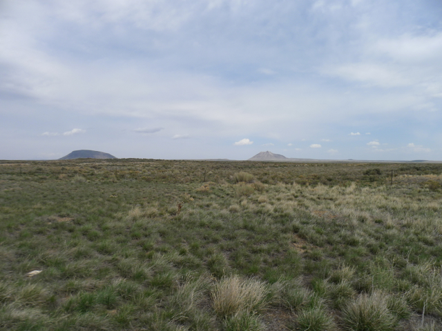
One of the first things you notice while driving through the sixty miles of arid, mile-high plain dominated by sagebrush and bunch-grass between Blackfoot and Arco (US-20W) is that the landscape is increasingly strewn with boulders of varying sizes, long ago hurled through the air by volcanoes. Cinder-black, these rocks are curiously warm to touch even on a cold April day: they bask in the radiation of the sun. Desiccated plants somehow flourish in the parched soil. Straight and flat, US-20W stretches into the distance flanked by the rhyolite lava dome of Big Southern Butte (300,000 years old and rising approx. 2500 ft.) to the left, and the smaller Middle and East Buttes to the right. Unsurprisingly, these massive structures remain important landmarks on this flat stretch of the eastern Snake River Plain. The route retraces the old covered wagon trail of Goodale’s Cutoff, a diversion from the Oregon Trail. In 1862 Tim Goodale led 338 wagons and almost 2000 people through here. Relations between Shoshone and the wagon trains had deteriorated along the regular, more southerly route and he promised a safer passage. A mountain man and long-time trader familiar with Native Americans and their trails, Goodale reopened a passage that had been tried ten years earlier by John Jeffrey and was already known as Jeffrey’s Cutoff. I imagine navigating without roads or maps, in wood-and-canvas wagons, and I’m reminded of Kelly Reichardt’s film of isolation and desperation in the eastern high desert of Oregon, Meek’s Cutoff (2010). Reichardt’s screenplay dramatises mountain man Stephen Meek’s attempt to lead a small group of pioneers by a shorter route than usual to the Willamette Valley. The conventions of regular wagon-train westerns are there: encounters with Indians, running out of water and finding only saline lakes, endless arid plains, sickness miles from anywhere, and a dysfunctional gender gap that tries to put women back in the wagons at the first hint of danger. But those commonplaces are confounded by an extended theme of communication breakdown. In his disastrous attempt to retain authority, Meek can only tell tall tales of fighting bears and Indians to a small boy (the one person he can hold spellbound). A lone Native American whom they find speaks a language that none of the group can understand, and nor can he comprehend them. For lack of interlocutors, he converses with the moon. Wary compassion on the part of one of the women comprises his only meaningful, non-violent opportunity for intercultural human exchange. A grey-green landscape dominates the film, withholding any features that can be translated into cartography by a human imagination. Furthermore, this third film in Reichardt’s Oregon trilogy uses cinematography and sound to convey the problem of trying to converse in the relentless, strong wind of a particular American west. Meek’s Cutoff may be set in Oregon, but it could easily be a story about where I’m standing. Back in our present world of comfortable car travel, Butte County Chamber of Commerce’s website has a History of Arco that provides an informative account of the traffic through and settlement of this part of Idaho.
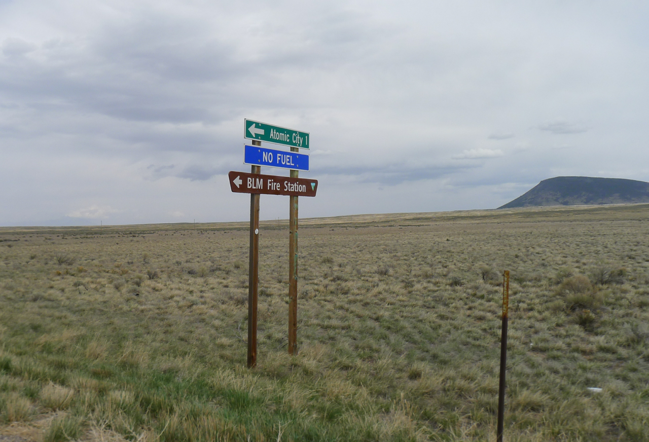
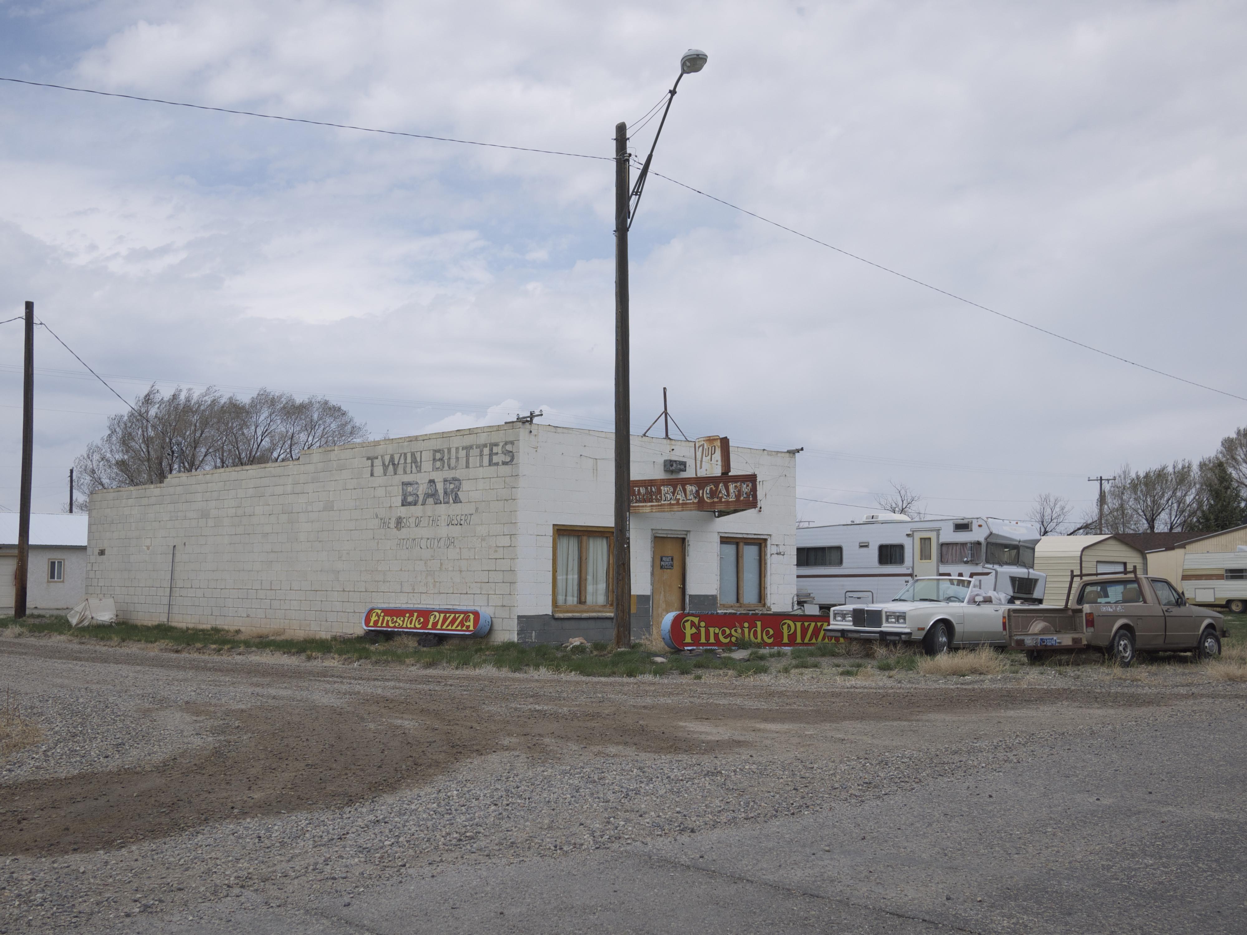
After a while, a road sign marks a junction to the extraordinarily named Atomic City. With a population of 29 in the 2010 census (that’s an increase on the 25 entered in 2000), this tiny community a few hundred yards off the main highway has a bar, a store and a stock car racing stadium. But as the sign on US-20W warns, there’s no gas for sale. Deserted buildings lend the town a movie-set atmosphere. Tumbleweed blows along the street. The only sound is the wind. Atomic City changed its name from Midway (indicating its position between Blackfoot and Arco) when Butte County became the site for the National Reactor Testing Station. More than fifty different kinds of nuclear reactor were built in a nine-hundred-square-mile area, to develop atomic energy and a nuclear naval capacity. Atomic City never matched the size of Arco, a few miles along the road and the first town in the world to be lit by atomic power. But its dogged persistence in surviving matches that of the plants and animals of the prairie.

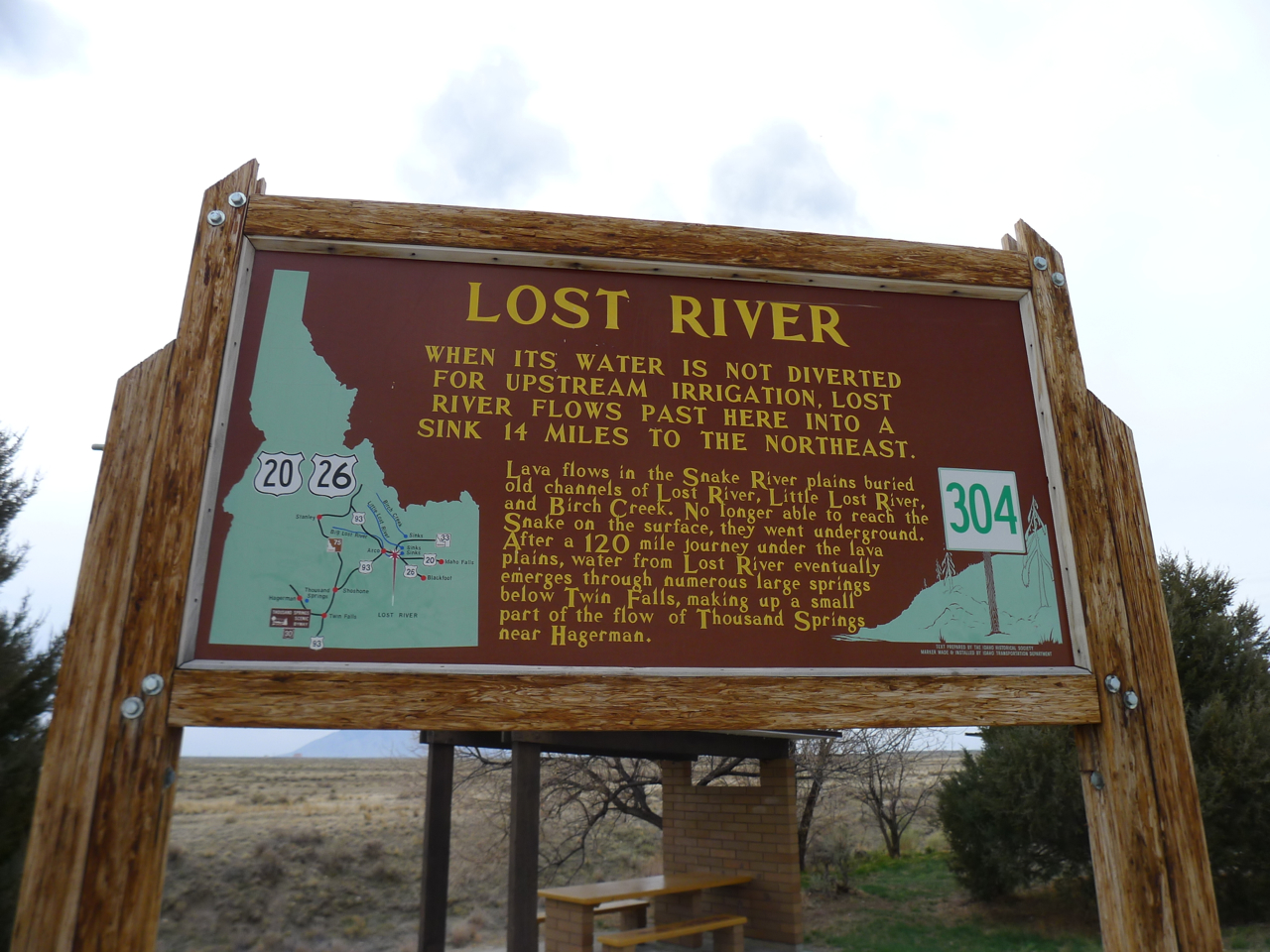
Back on the highway, larger signs announce the Idaho National Laboratories industrial and research complexes, the Department of Energy STAR Voluntary Protection Program (‘Visitors: all injuries are viewed as preventable’) and the Atomic Museum. I wanted to visit the museum, which is housed in the decommissioned reactor EBR1 that lit Arco. Unfortunately, it is closed at this time of the year. It’s now also a National Historic Landmark. Visitors have compared it with the Smithsonian Air and Space Museum for interest. Instead, we settled for a picnic at a rest area overlooking the dry bed of the Lost River . . . a water source which has disappeared, as its name implies.

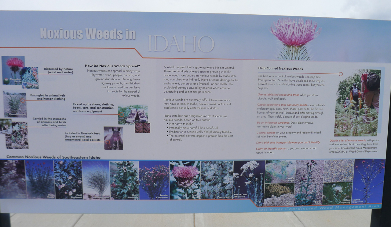
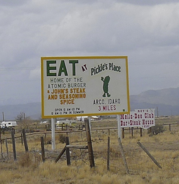
Information boards around the rest area display a basic narrative of the potential for massive destruction as well as cheap power that is all around, while warning about the damage that can be done by introducing non-native plants and animals to what is a fragile and beautiful ecosystem. I like the final emphasis on the delicacy and value of life, and try to convince myself that it implies enough concern for the environment that we share to indicate a sense of hope. Arco, a few miles further along the road, with a population of 995 in 2010, still greets visitors with an advertisement for Pickle’s Place, ‘Home of the Atomic Burger.’ Well, we’d had lunch. . .
My mind skips to cinema again, but this time to Richard Lester’s Superman II (1980) in which arch-villain Lex Luther’s Kryptonian sidekicks turn up in the fictional small Idaho town of East Houston to wreak havoc with their heat-ray vision. A boy who leaps onto a horse to ride for help is killed by one of the intruders, without having the opportunity to ‘grow into a man.’ Aliens? Maybe that’s going too far . . . or could the controversial scene in a feel-good family movie and TV series allude to a more real and present danger? In 1961 the U.S.’s only known deaths directly attributable to a reactor accident took place in this area near Arco. A steam explosion at NRTS Reactor SL-1 initiated a partial core meltdown, and three operatives died. Books have been written about the incident, films have been made, official papers published, and there’s a video on YouTube.
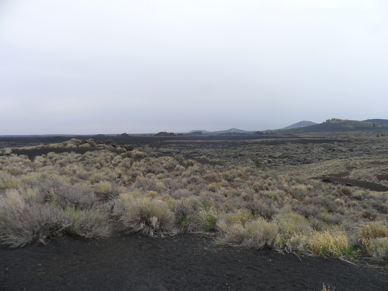
Enough of atomic power and superheroes. Most people who travel this route also visit the 1,100 square-mile Craters of the Moon National Monument and Preserve. Craters of the Moon is a spectacular demonstration of the violence that nature itself can wreak and another affirmation of the triumph of life. The entire area is a black-soiled, burned lava field resulting from a volcanic eruption 2000 years ago. In 1901 Israel Russell, of the U.S. Geological Survey, described the main formations as ‘cinder buttes,’ capturing their charred appearance. I’m interested in periodical journalism. Robert W. Limbert’s 1924 article for National Geographic that led to the creation of this National Monument is worth reading, courtesy of the Park Service website. The wind here was even stronger than on the atomic plain. There was no possibility of walking any meaningful distance. Again, the site is replete with a history that is more than geological and that puts in question the use of the term ‘wilderness’ on an information board (it’s a wild place, granted). Jean Baptiste Charbonneau, a member of Lewis and Clark’s expedition and later a trapper working for the American Fur Company, nearly died near here in 1831. Tim Goodale and his wagon train passed nearby. Shoshone are among the people who have moved through the area across centuries. The deeper ecology is particularly interesting, for plant, animal and bird life is diverse and flourishing. Antelope bitterbrush (Purshia tridentata) grows on the bare black earth while limber pine (Pinus flexilis) and juniper are the dominant trees. Islands of localized vegetation, called Kipukas, are home to some rare species. I saw a yellow-bellied marmot – a sub-species unique to Craters of the Moon – and a ground squirrel, possibly also of the kind found only locally. Spatter cones, lava tubes and cinder buttes give the place its name. One is called ‘Inferno Cone,’ perhaps alluding to Dante’s poem. The information sheets claim that Big Cinder Butte, at 700 feet above the plain, is one of the largest purely basaltic cinder cones in the world. We peer into spatter cones, while listening to the wind.


I am minded to consider whether we are arrogant to presume that we have the ultimate power to destroy or save this planet on which we live our precarious existence. Here, in an environment that evokes the burring marle from Milton’s Paradise Lost, life goes on . . . although it’s no place for humans.
The drive on to Boise takes us along river valleys and more plains, with pasturage on either side of the highway. Two women in a roadside coffee house in Carey say they are praying for rain, that there was little snow for the third winter running, and that the reservoirs are seriously low. Their calling for rain in what is a desert of the American West participates in a rite that stretches across cultures to origins in much earlier Native American societies. This is Hemingway country, too. I’m told that E.H. fished these streams lined with tall cottonwoods and vivid, sprouting willows. He eventually shot himself at his home built of cinder blocks designed to look like wood, in nearby Ketchum.
We see sandhill cranes in tilled fields, and wind up and then down through mountain passes until Boise comes into view, around a corner and just a couple of miles in front of us. It is like an oasis. A city of trees, as its name (from the French boisé) implies. Basque shepherds have settled here, relatively recently. The rain finally falls steadily, from a lead-gray sky. I’ll write about Boise hospitality, the Guernica Tree, red-tailed hawks, ospreys, and cutthroat trout in my next post.


Pingback: City of Trees: Boise, Idaho and an Urban Natural Experience. | Susan Oliver